Rome NY: Geographic And Environmental Foundations
The story of Rome, New York, begins with the land itself, a special place shaped by ancient ice and flowing water that dictated its strategic importance for centuries.
"Controlling this special place meant controlling travel and trade for an entire continent."
The story of Rome, New York, begins with the land itself, a special place shaped by ancient ice and flowing water. Long ago, massive sheets of ice, like frozen rivers miles high, covered much of North America. As these glaciers slowly melted and retreated, they carved and molded the landscape. They left behind a wide, flat valley in the heart of New York. This valley was once the floor of a vast body of water called Glacial Lake Iroquois. The lake was so large that it stretched for hundreds of miles. When the lake finally drained, it left behind deep layers of sand and gravel. This created a smooth, open plain, a perfect canvas for the city that would one day be built there. The ground beneath the sand and gravel is made of strong, solid rock called shale and sandstone. This firm foundation made the land stable and safe for building. The flat terrain and soft, sandy soil would one day make it much easier for people to dig and build amazing things. It was a place full of potential, waiting for people to discover its secrets.
Through this flat plain, two important waterways began to flow, like great pathways pointing in opposite directions. The Mohawk River is a strong and steady river that travels eastward. It flows for many miles until it joins the great Hudson River, which then continues south to the Atlantic Ocean. This river was a natural highway to the sea. In the other direction, a smaller stream called Wood Creek trickled westward. Wood Creek leads to the wide expanse of Oneida Lake. From Oneida Lake, other rivers and streams connect to the Great Lakes, which are like giant freshwater seas in the middle of the continent. The land separating the Mohawk River and Wood Creek was very narrow. This short stretch of dry ground was called the Oneida Carrying Place. For thousands of years, it was one of the most important places in all of North America. Native peoples, especially the members of the powerful Haudenosaunee Confederacy, used this path to carry their canoes and goods from one waterway to the other. It was a key link in a trade network that connected communities from the Rocky Mountains to the eastern forests. Controlling this special place meant controlling travel and trade for an entire continent.
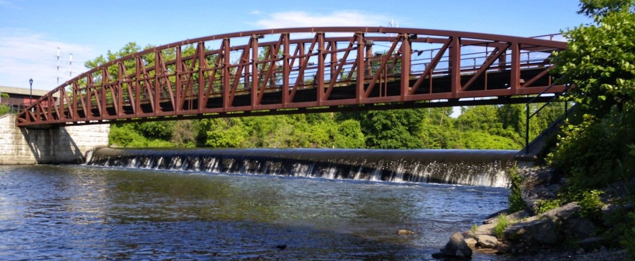
The land in Rome holds another secret, a feature that is easy to miss but is incredibly important. At a place now marked by Bellamy Harbor Park, the ground reaches its highest point in the area. This spot is a hydrological summit, which is a special term for a peak where water flows away in two different directions. If you were to pour a bucket of water on this exact spot, some of the water would begin a long journey east down the Mohawk River valley, while the rest would travel west toward the Great Lakes. This natural feature made Rome the perfect place to begin building the famous Erie Canal. On July 4, 1817, the first shovels of dirt were dug here. The engineers who designed the canal understood that they could use the power of gravity. By starting at this high point, they could let the water in the canal flow downhill to the east and downhill to the west. This clever plan made the canal work without needing lots of expensive machines to pump the water. It was a work of genius that used the land’s own shape to connect the entire state.
The water for this amazing system comes from the Upper Mohawk River watershed. A watershed is an area of land where all the rain and melting snow drains into a single river. The Mohawk’s watershed collects water from the hills of the Adirondack Mountains and the Tug Hill Plateau. In the past, the river could be wild and unpredictable. In the spring, melting snow could cause the river to flood, washing away homes and farms. To control the river and to make sure the new Barge Canal always had enough water, a great dam was built north of Rome in 1908. This was a huge project that created a brand new lake, called Delta Lake. The lake acts like a giant storage tank. It holds water back to prevent floods and releases it slowly to keep the canal full all year long. Creating this lake required a great sacrifice. The entire village of Delta, with its homes, churches, and cemeteries, was slowly covered by the rising water. Today, Delta Lake provides the region with a safe, steady supply of water and is also a beautiful place for boating, fishing, and swimming, a peaceful place born from a great challenge.
Thoughts for Insight
- The retreat of ancient glaciers created the flat, sandy plain that made Rome an ideal location for settlement and construction.
- The city's location at the meeting point of the Mohawk River and Wood Creek established it as a critical crossroads for continental travel.
- The Oneida Carrying Place was the essential land bridge that connected two vast water networks, making it a point of immense strategic value.
- Rome's position on a hydrological summit was a key geographical advantage that enabled the gravity-fed engineering of the Erie Canal.
- The creation of Delta Lake demonstrates how people can reshape the environment to manage natural resources and support ambitious infrastructure.
--